

Dienstag, 30. Juli 2013


Freitag, 26. Juli 2013
Bye, bye Pakistan

All of us for sure will come back to this wonderfull country and its
friendly people.
My next destination is Tanzania. A dream comes true. With the whole family
(my wife Heike & 5 children) we will visit Tanzania, climb Mt Meru and of
course do a lot of safaris.
Search and Rescue operation (SAR) for three lost Iranian climbers on Broad Peak


Peak
18. July 2013
Together with 7 clients and 1 HAP I summited Gasherbrum II and descended to
camp 3.
19. July 2013
From camp 3 I skied and climbed down to basecamp.
20. July 2013
We packed our equipment in BC and at 12:00 we started our trekking back to
Askole. First stop should be Concordia.
On the way down to Concordia Naiknam Karim got in touch with me (Thuraya)
and asked for help on Broad Peak. He told me three Iranians are stranded in
camp 4 and are not able to descend.
I offered my help, but only if an army helicopter would set me up between
6000 and 6500m together with oxygen. I asked him also about the possibility
of a sling rescue (which I was willing to do) higher up the mountain.
Naiknam wanted to get in touch with the army und discuss the possibilities
of a helicopter rescue in extreme altitude.
Later in the evening he called me back. The army offered to set me up on the
mountain as high as possible the next day. They denied a sling rescue.
Naiknam told me that meanwhile only one Iranian climber is alive (he called
his hometeam on July 19th) and this one is somewhere arround camp 4. I asked
for 3 bottles of oxygen, 2 maskes and 2 regulators.
My idea was to climb up to this mountaineer, give him a dexamethason
injection and oxygen and descend with him to 6500 m where the helicopters
could pick us up.
21. July 2013
My group left at 5:00 am Concordia. I was waiting in my downsuit until 8:00
am when two Ecureuil AStar AS 350 helicopter from the Pakistan army landed
(the best high altitude SAR helicopters).
We did 3 flights up to 8000m - the limit of the helis - on BP and made
photos of the area we thought they are. I was always in my downsuit ready to
drop out, if we see someone. But we saw nobody, not even any sign of the
three missing climbers. We mainly searched in the rocks of the forsummit
(called rocky summit).
Back in Skardu we checked the photos but had also no findings. Later the day
we got the coordinates of the last phonecall from Thuraya / UAE. With google
earth we found the location on the mountain and again checked my photos -
nothing. It looked like the climbers took the wrong ridge down from rocky
summit of BP. The last call was made at arround 7500m in a rocky area on the
Pakistani side of the mountain. The climber from Iran who did the last call
told his home team that he is off the normal route surrounded by rocks but
could see the tent of camp3.
With this information and the coordinates of the Thuraya call, we marked the
possible aerea where this person could be on an arial photo I made.
22. July 2013
The Iranian embassy asked for a second search-flight with my participation.
"It was not my idea to fly again up to Broad Peak, but tomorrow morning will
be the last chance to locate persons or bodies on the mountain. From
tomorrow until 26th bad weather moves in and snow might cover everything. I
will not carry any rescue equipment because of changing weather it is not
possible to do a rescue. More or less we will try to locate the bodies of
the climbers for a maybe later evacuation. We believe all of them are
dead -sorry! I am actually somehow scared about our flights tomorrow because
we are flying at the limit of the helicopters when flying that high. I will
risk my life to locate these bodies because there seams to be nobody else
arround."
23. July 2012
We tried to start early with the helicopters from Skardu. The earlier, the
colder the air and the higher the helicopters can fly. Due to clouds in the
approaching valley we reached Broad Peak BC as late as 9:00 pm. Helicopters
can only fly on sight ! In BC we waited again for a big hole in the clouds
to fly up to the summit region. But bad weather moved already in. High wind
and clouds prevented us to fligh higher than 7500m. The upper part of the
mountain was covered in clouds and it was already snowing. No chance to
reach the area we wanted to search for the bodies. By 12:00 we called the
search flights off and flew back to Skardu.
16:00 press conference in Skardu
"Today there was a final press conference in Skardu where I could state my
opinion. I strongly believe none of the three Iranian climbers is alive
anymore, due to the high aktitude where they are now for one week and
dehydration. My second statement is, that there is no chance to evacuate
their bodies because they are far away from the normal route in an altitude
of minimum 7500 m. Helicopters will only evacuate people/bodies up to 5800m.
Higher up everything has to be done by humans. There have been evacuations
before in this altitude but only on the normal route. We do have two clues
where the bodies might be: 1) last thuraya phone call and 2) yellow spot on
a photo. Both locations are above 7500m off the normal route and 500m in
altitude away from the summit and the normal route. No chance for
evacuation!
I believe as a moutaineer these three climbers don't want to risk someones
life to get their dead bodies down. Two porters found the Iranian flag on
top of the main summit. Therefore the Iranian route on BP was sucessfully
completed by the three climbers. It seams they took the wrong ridge down the
rocky summit - the only mistake they made !"
Thomas Laemmle
sports scientist
high altitude physiologist
expedition leader
Mittwoch, 24. Juli 2013
SAR operation on Broad Peak for 3 lost Iranians


two flights with "high altitude helicopters" (=mystery chopper) - belonging
to the 5th Pakistan Army Aviation Squadron -
up to an altitude of 8000m. The goal was to find 3 Iranian climbers high up
on the mountain.
More information in a following post.
Dienstag, 23. Juli 2013


Freitag, 19. Juli 2013
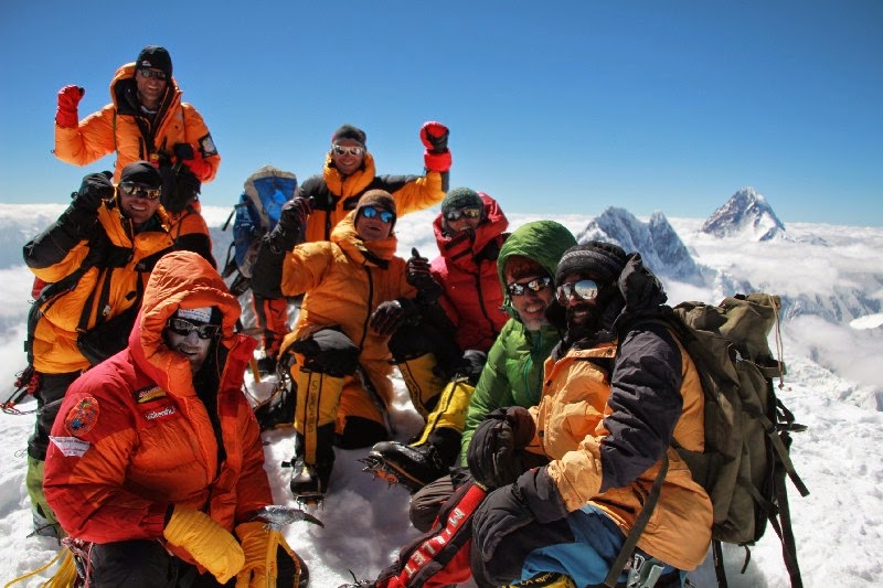
AMICAL summited Gasherbrum II on July 18th at 14:00
On July 18th at 14:00 the AMICAL members Helga, Juergen, Joerg, HG,
Bastian, Charly and Klaus together with guide Thomas and HAP Ali summited
Gasherbrum II. Responsible for the perfect weather during this day was
Charly Gabl from Innsbruck. He hold us three days in camp 3 to receive this
present. Thomas had to fix another 300m of rope on the steep summit face
,the last 20m to the very top are prepared with a rope he got three weeks
ago from Artur Hajzer. In memorial of this great Polish mountaineer,
climbers will reach G II this season with the help of his rope.
Donnerstag, 18. Juli 2013
PIEPS GlobalFinder message from: 210049
SUMMIT G2 14;00 - 7 CLIENTS , ALI, THOMAS
210049 has sent this message on: 18-07-2013 10:52:55 UTC
from position: latitude 35.75661°, longitude 76.65669°, altitude 7742m
You are welcomed to check 210049 shared track Gasherbrum I und II Expedition.
NOTE: 210049 has send this emial via satellite using PIEPS GlobalFinder.
You may answer to this e-mail, but you've to consider that the overall clear-text message size must not exceed 256 characters (including your email-address) for satellite transmision.
If the email size will exceed 256 characters, it'll be truncated. Subject is not transferred.
PIEPS GlobalFinder message from: 210049
NEAR SUMMIT RIDGE WAITING FOR ROPE
210049 has sent this message on: 18-07-2013 07:57:15 UTC
from position: latitude 35.75776°, longitude 76.65368°, altitude 7960m
You are welcomed to check 210049 shared track Gasherbrum I und II Expedition.
NOTE: 210049 has send this emial via satellite using PIEPS GlobalFinder.
You may answer to this e-mail, but you've to consider that the overall clear-text message size must not exceed 256 characters (including your email-address) for satellite transmision.
If the email size will exceed 256 characters, it'll be truncated. Subject is not transferred.
PIEPS GlobalFinder message from: 210049
SHORTLY BELOW SUMMIT STEEP FIXING 300m ROPE
210049 has sent this message on: 18-07-2013 06:34:25 UTC
from position: latitude 35.75747°, longitude 76.65456°, altitude 7923m
You are welcomed to check 210049 shared track Gasherbrum I und II Expedition.
NOTE: 210049 has send this emial via satellite using PIEPS GlobalFinder.
You may answer to this e-mail, but you've to consider that the overall clear-text message size must not exceed 256 characters (including your email-address) for satellite transmision.
If the email size will exceed 256 characters, it'll be truncated. Subject is not transferred.
PIEPS GlobalFinder message from: 210049
CHINESE SIDE 7800m - 8 CLIENTS, ALI + THOMAS
210049 has sent this message on: 18-07-2013 06:34:07 UTC
from position: latitude 35.75747°, longitude 76.65456°, altitude 7926m
You are welcomed to check 210049 shared track Gasherbrum I und II Expedition.
NOTE: 210049 has send this emial via satellite using PIEPS GlobalFinder.
You may answer to this e-mail, but you've to consider that the overall clear-text message size must not exceed 256 characters (including your email-address) for satellite transmision.
If the email size will exceed 256 characters, it'll be truncated. Subject is not transferred.
PIEPS GlobalFinder message from: 210049
8 AMICAL MEMB ABUVE 7550m
210049 has sent this message on: 18-07-2013 01:32:14 UTC
from position: latitude 35.75544°, longitude 76.6537°, altitude 7681m
You are welcomed to check 210049 shared track Gasherbrum I und II Expedition.
NOTE: 210049 has send this emial via satellite using PIEPS GlobalFinder.
You may answer to this e-mail, but you've to consider that the overall clear-text message size must not exceed 256 characters (including your email-address) for satellite transmision.
If the email size will exceed 256 characters, it'll be truncated. Subject is not transferred.
Mittwoch, 17. Juli 2013
PIEPS GlobalFinder message from: 210049
PLAN FOR TODAY: 23:00 START TO G2 SUMMIT FROM CAMP 3 - 6950m - 8 CLIENTS+2PORTERS+1GUIDE
210049 has sent this message on: 17-07-2013 03:38:11 UTC
from position: latitude 35.74847°, longitude 76.64559°, altitude 6982m
You are welcomed to check 210049 shared track Gasherbrum I und II Expedition.
NOTE: 210049 has send this emial via satellite using PIEPS GlobalFinder.
You may answer to this e-mail, but you've to consider that the overall clear-text message size must not exceed 256 characters (including your email-address) for satellite transmision.
If the email size will exceed 256 characters, it'll be truncated. Subject is not transferred.
Dienstag, 16. Juli 2013
PIEPS GlobalFinder message from: 210049
TODAY AMICAL MEMBERS THOMAS AND FRITZ DESCENDED TO C2. THE OTHER 8 MEMBERS ARE DOING GOOD!
210049 has sent this message on: 16-07-2013 11:28:44 UTC
from position: latitude 35.74853°, longitude 76.64553°, altitude 6967m
You are welcomed to check 210049 shared track Gasherbrum I und II Expedition.
NOTE: 210049 has send this emial via satellite using PIEPS GlobalFinder.
You may answer to this e-mail, but you've to consider that the overall clear-text message size must not exceed 256 characters (including your email-address) for satellite transmision.
If the email size will exceed 256 characters, it'll be truncated. Subject is not transferred.
PIEPS GlobalFinder message from: 210049
WEATHER INFO FROM CHARLY GABL SAYS: 18.07. SUMMIT DAY!
210049 has sent this message on: 16-07-2013 11:21:55 UTC
from position: latitude 35.74853°, longitude 76.64553°, altitude 6964m
You are welcomed to check 210049 shared track Gasherbrum I und II Expedition.
NOTE: 210049 has send this emial via satellite using PIEPS GlobalFinder.
You may answer to this e-mail, but you've to consider that the overall clear-text message size must not exceed 256 characters (including your email-address) for satellite transmision.
If the email size will exceed 256 characters, it'll be truncated. Subject is not transferred.
Montag, 15. Juli 2013
PIEPS GlobalFinder message from: 210049
HAD TO GIVE UP SUMMIT PUSH AT CAMP4 - 7400m - FIXED ALL ROPE DOWN TO C3 - BAD WEATHER
210049 has sent this message on: 15-07-2013 11:58:14 UTC
from position: latitude 35.74857°, longitude 76.64558°, altitude 6955m
You are welcomed to check 210049 shared track Gasherbrum I und II Expedition.
NOTE: 210049 has send this emial via satellite using PIEPS GlobalFinder.
You may answer to this e-mail, but you've to consider that the overall clear-text message size must not exceed 256 characters (including your email-address) for satellite transmision.
If the email size will exceed 256 characters, it'll be truncated. Subject is not transferred.
PIEPS GlobalFinder message from: 210049
ALL 10 AMICAL MEMBERS ARE IN CAMP3 - WEATHER STORMY AND CLOUDY - WAITING INFO CHARLY GABL
210049 has sent this message on: 15-07-2013 11:50:39 UTC
from position: latitude 35.74857°, longitude 76.64558°, altitude 6956m
You are welcomed to check 210049 shared track Gasherbrum I und II Expedition.
NOTE: 210049 has send this emial via satellite using PIEPS GlobalFinder.
You may answer to this e-mail, but you've to consider that the overall clear-text message size must not exceed 256 characters (including your email-address) for satellite transmision.
If the email size will exceed 256 characters, it'll be truncated. Subject is not transferred.
Abonnieren
Posts (Atom)